| Author | Thread |
|
|
09/09/2008 07:36:10 PM · #1 |
Normally I don't have much of a back story to my pics--but my recent FS entry has a bit of one. 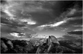 The title refers to Royal Robbins, apparently the first guy to climb the face, and at the ripe old age of 21. "Hey Mom, guess what I'm going to do next Saturday?"... Plus he is a local Modestoan. The title refers to Royal Robbins, apparently the first guy to climb the face, and at the ripe old age of 21. "Hey Mom, guess what I'm going to do next Saturday?"... Plus he is a local Modestoan.
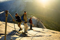
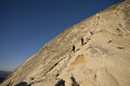
"YOu can't eat an elephant in one bite," said my wife as we enjoyed the sunset at Glacier Point in Yosemite last month. I had multiple opportunities to repeat this little fun fact between gulps of oxygen and delectable morsels of Power Bars (or their imitators) while night hiking the summit a few hours later.
From Glacier Point, Half Dome looks close enough to touch, I'm guessing 2 or 3 miles as the crow flies. However, the hike between them is a little longer, about 10.5 miles. Our group consisted of my wife, my dad, brother in law, and another friend. I knew what the hike was all about, this being my 4th time; walk uphill for a long time, then turn around and walk downhill for a slightly shorter length of time. (90% mental and 50% physical to paraphrase Yogi Berra) Our plan was to leave Glacier Point in time to make it the top of HD for sunrise. Our group was comprised of my wife and I, my dad, brother in law, and another friend. My wife and I had both been to the top but the others were HD virgins. Here is an approximation of our route for your viewing pleasure. 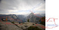 Everything went splendidly, made it to the top by 5:00 and froze for an hour or so waiting on the sun. I won't bore you with too many details as lots of people have hiked HD and written extensive trail guides on the same. Everything went splendidly, made it to the top by 5:00 and froze for an hour or so waiting on the sun. I won't bore you with too many details as lots of people have hiked HD and written extensive trail guides on the same.
I rank the hike 10/10 for difficulty and a near 10/10 for scenic value. Never hike it during the day on a summer weekend unless you want to endure a Los Angeles sized traffic jam on or approaching the cables. Don't hike it until the forest service hangs the cables in May. Parts of the cable route are greater than 45 degrees. And stay off the top during a lightning storm. Otherwise, if you are visiting Yosemite, try to work it in. Heck, PM me and I'll help you plan your trip although I won't guarantee I'll join you! :) Here are a few pics and the rest can be found at www.pbase.com/cantbreakpar.
   |
|
|
|
09/09/2008 08:07:33 PM · #2 |
|
those are incredible ... now that's on my list of things to do ... I've hiked the Inca Trail in Peru, so I *should* be able to tackle this one ... thanks for sharing ... |
|
|
|
09/09/2008 08:35:21 PM · #3 |
Those are FABULOUS photos and a really fun narrative, but...
Don't worry. You'll get over all of this need to climb and such. Soon you will sit on the sofa and eat ice cream like the rest of us instead of doing all of these wild activities. *grin*
I'll enjoy more of these stories until you get to the ice cream stage, if you have them, though. *grin*
|
|
|
|
09/09/2008 08:39:53 PM · #4 |
Originally posted by LydiaToo:
Those are FABULOUS photos and a really fun narrative, but...
Don't worry. You'll get over all of this need to climb and such. Soon you will sit on the sofa and eat ice cream like the rest of us instead of doing all of these wild activities. *grin*
I'll enjoy more of these stories until you get to the ice cream stage, if you have them, though. *grin* |
I like ice cream. :) The "Inca Trail" sounds fun... |
|
|
|
09/10/2008 10:35:29 AM · #5 |
Having done chunks of the hike last spring, I can attest to the level of difficulty. Doing the entire hike overnight sounds insane! :-)
I *love* the trail map, it's totally accurate, although I think I remember more switchbacks. Looking at the thumbnail, I thought I was looking at someone's Christmas card.
Message edited by author 2008-09-10 10:36:28. |
|
|
|
09/10/2008 11:03:09 AM · #6 |
|
Appreciate the story behind the shot! A lot of photography, to me anyway, includes the stories behind the shots. You guys are seriously nuts, but in a good way. Thanks for sharing the adventure! |
|
|
|
09/10/2008 11:03:19 AM · #7 |
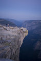
You might have hiked the more traditional route starting at the valley floor. A little shorter than starting at Glacier Point(8.5 vs 10.5) but ALL uphill, including many torturous granite steps/switchbacks. I've done both routes and they are both uugggghhhh!
The part of the trail from the valley to the top of Nevada falls is really cool, especially in the spring when the falls are rushing. Prepare to get wet!
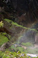 Looking down at part of the mist trail, spring of 05. Looking down at part of the mist trail, spring of 05.
|
|
Home -
Challenges -
Community -
League -
Photos -
Cameras -
Lenses -
Learn -
Help -
Terms of Use -
Privacy -
Top ^
DPChallenge, and website content and design, Copyright © 2001-2026 Challenging Technologies, LLC.
All digital photo copyrights belong to the photographers and may not be used without permission.
Current Server Time: 07/30/2026 11:59:54 AM EDT.


