| Author | Thread |
|
|
06/13/2011 05:18:38 PM · #1 |
We are going to be taking a 12 day camping trip in North Carolina's Stone Mountain State Park, Virginia's Douthat State Park and Grayson Highlands State Park. Also Colleton State Park in SC (this is a stop on the way home).
I know that I will be by the Shenandoah Mountain National Park, Blue Ridge Parkway, George Washington National Forest, Jefferson National Forest. We are also going to take a day and head over to Babcock State Park in West Virginia. Our dog will be with us, he is a Lab so I need places that will allow dogs as much as possible, we can leave him at the trailer but he isn't very happy. So alot of hiking this trip.
1) Looking for interesting things to do
2) Trying to get out of the heat of Florida (don't think I will succeed in this)
3) Would love to meet up with anyone in the area
I have scouted out alot of waterfalls, but I don't which ones to target - we also love history - old ruins etc. There is an old iron works not far from where we will be.
Thanks for the suggestions.... |
|
|
|
06/13/2011 05:49:56 PM · #2 |
Blue Ridge Pkwy...mile marker 51 is Big Meadow. Lots of opportunities to get up close and personal with the deer, especially the babies. First two weekends in JUN is usually when they are born, and best to get the tiny baby shots, but you'll get plenty of good photos of them with their Moms all summer. Early morning, late afternoon/early evening are usually great. Talk to the folks who are staying at the campground...there's usually a lot of bear sightings there in the evenings. Wish I was home in VA, I'd go with...we love it up there.
|
|
|
|
06/13/2011 06:02:31 PM · #3 |
I'm more familiar with areas surrounding Asheville, Maggie Valley, Lake Lure, Chimney Rock, Waynesville , parts of Pisgah National Forest and Black Mountain - which is quite away aways from Stone Mountain State Park.
However there is this great website that shows points on the interactive map of waterfall locations. If you click on the blue markers it will show a small pop-up window with name & description of waterfall as well as provide a website link that gives greater details. It is a great resource that I used for our trips up to NC. As that you will be at Stone Mountain Park the place closest to the below map is just south of Sparta
North Carolina Waterfalls |
|
|
|
06/13/2011 06:36:40 PM · #4 |
| Janine - Dark Hollow Falls is right next to Big Meadows...if you end up planning that as a stop let me know. |
|
|
|
06/13/2011 07:22:04 PM · #5 |
I am near Bedford, Va and the parkway. If you want a tough hike with the best view (360 degree) then you have to hit Sharp Top at the Peaks of Otter. They have a bus that will take you most of the way if you want. Also in the same area is abbot lake
This is the lake with Sharp Top behind it 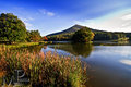 Crab Tree Falls is pretty close and while I have not hiked it I have heard it is excellent. Falling Cascades is close to The Peaks of Otter but it all depends on the rain and whatnot as to whether or not the falls will be flowing well. Crab Tree Falls is pretty close and while I have not hiked it I have heard it is excellent. Falling Cascades is close to The Peaks of Otter but it all depends on the rain and whatnot as to whether or not the falls will be flowing well. |
|
|
|
06/13/2011 07:30:25 PM · #6 |
Originally posted by glad2badad:
Janine - Dark Hollow Falls is right next to Big Meadows...if you end up planning that as a stop let me know. |
we definitely will be going on the Blue Ridge Parkway for sure...I've pulled out my "guides" and will have to look up both of these places...Rick (husband) is really looking forward to this day of adventure and he's soooo good about letting me stop anywhere I like....
We will have Tue/Wed/Thur to explore anywhere in the that area...when we are going further South we are going to go to the Farm/Meadow of Mary Ingles from the book Follow the River by James Alexander Thom. I know that we have a day of Waterfalls that we want to do in West Virginia near Babcock State Park.
Does anyone know much about the Iron Works at Roaring Run Furnace more details it just looks interesting.... |
|
|
|
06/13/2011 07:31:35 PM · #7 |
Originally posted by MinsoPhoto:
I am near Bedford, Va and the parkway. If you want a tough hike with the best view (360 degree) then you have to hit Sharp Top at the Peaks of Otter. They have a bus that will take you most of the way if you want. Also in the same area is abbot lake
This is the lake with Sharp Top behind it Crab Tree Falls is pretty close and while I have not hiked it I have heard it is excellent. Falling Cascades is close to The Peaks of Otter but it all depends on the rain and whatnot as to whether or not the falls will be flowing well. |
how have the water levels been...I'm hoping the water is flowing really nice... |
|
|
|
06/13/2011 07:38:02 PM · #8 |
Originally posted by CNovack:
I'm more familiar with areas surrounding Asheville, Maggie Valley, Lake Lure, Chimney Rock, Waynesville , parts of Pisgah National Forest and Black Mountain - which is quite away aways from Stone Mountain State Park.
However there is this great website that shows points on the interactive map of waterfall locations. If you click on the blue markers it will show a small pop-up window with name & description of waterfall as well as provide a website link that gives greater details. It is a great resource that I used for our trips up to NC. As that you will be at Stone Mountain Park the place closest to the below map is just south of Sparta
North Carolina Waterfalls |
Chrystyne - this is a fabulous website!!! We've been all around the areas that you've been to as well (my parent had land/homes in Highlands/Franklin, NC) I tried to find a similar one for Virginia...but not yet I've filed this in my Places to Photograph...thank you. We are going to be very close to about 3 of these falls near Sparta/Mt. Airy and we have 3 nights in that area... |
|
|
|
06/13/2011 08:58:52 PM · #9 |
| I'd have to second Peaks of Otter...fabulous place to visit, tons of photo ops. |
|
|
|
06/13/2011 09:28:26 PM · #10 |
| We had a good deal of rain early in the Spring but it has been warmer then usual and pretty dry so I doubt they will be that high. Crabtree Falls I believe runs pretty well year round but the Falling Cascades really dries up in the Summer. You should be able to call a information number and ask a ranger how they have been. |
|
|
|
06/13/2011 10:04:48 PM · #11 |
Originally posted by LindaLee:
I'd have to second Peaks of Otter...fabulous place to visit, tons of photo ops. |
will I need oxygen tanks??? you gotta remember I live at about 100/125' above sea level...lol |
|
|
|
06/14/2011 12:05:24 PM · #12 |
| Nah it is only 3865 feet above sea level. Your ears will pop but breathing should be fine. Here is some info on sharp top trail. LINK |
|
|
|
06/14/2011 04:45:05 PM · #13 |
Originally posted by glad2badad:
Janine - Dark Hollow Falls is right next to Big Meadows...if you end up planning that as a stop let me know. |
I just read some of the SNP info...we can't take Rider (dog) on the Dark Hollows trail...but it says it's about a 3 hour hike (more like 6 for me!!!) and he can stay in the camper while we do it...not our first choice but not our first time either...really looks like a good hike with alot of falls.
IF you had a day to choose which do you think you could meet us? Tue/Wed/Thur? |
|
|
|
06/15/2011 12:45:07 PM · #14 |
Originally posted by MinsoPhoto:
Nah it is only 3865 feet above sea level. Your ears will pop but breathing should be fine. Here is some info on sharp top trail. LINK |
Joshua, your not to far from where we will be do you want to join us for an outing? We are in your area from Jun 27 to Jul 1st, so we would have Tue/Wed/Thur to go out and shoot. Waiting to hear from Wendy, Barry & Jimmy if they can do anything on those days or not...I know everyone has work schedules and we are on vacation but at this point we can probably work around everyone's schedules???
here is basically what we want to do:
Looking for this Iron Works it is just South of where we will be then on Dark Hollow Trail, Big Meadows more of the Blue Ridge Parkway (looking for waterfalls).
Looking an old deserted Resort called Blue Sulphur Springs and Babcock State Park, and Mills Creek Falls and Cathederal Falls (all of the falls are north of Babcock and probably to far away) maybe we would do better to head north and back east towards where we are going to be staying Big Ditch Lake or Middle Falls of Hill Creek and Fertile Prairie. Now that I'm looking at it Cathedral Falls is a bit far IMO for one day and in the wrong general direction.
Would like to go towards Monticello...but I doubt that they will let us in with a dog...therefore we need to find something else for the 3rd day...I wouldn't mind exploring Purgatory Creek, Jennings Creek. This day is totally up for grabs.... |
|
|
|
06/21/2011 02:53:54 PM · #15 |
| Sadly it doesn't look like I would be able to get off of work. I am getting ready to have a week off in July so I am sorry. I hope you enjoy the area though and let me know if there is anything I can do for you. |
|
|
|
06/21/2011 03:25:56 PM · #16 |
| awww... you'll miss all the fun! |
|
|
|
06/21/2011 04:22:56 PM · #17 |
Just to let ya'll know...
we have a little GTG going on...
On Tue, Jun 28th we are going to meet at the parking lot at Big Meadows marker 50.1 (ish) on the Shenandoah National Park Skyway. We are going to hike Rose River Falls. Here is the link to the thread that we have going - if your interested just let us know.
So far these are the ones that are definitely going....
 SJCarter SJCarter
glad2badad
 vawendy vawendy
Ja-9
 toddhead toddhead
sempermarine
We are working on.....
MaryO
 nova nova
Come join us if you can...
Message edited by Neil - per request...removed link to pm thread. |
|
|
|
06/21/2011 06:33:36 PM · #18 |
There is parking near Rose River Falls at mile post 49 (49.4). With your RV it may be tricky...not sure. Big Meadows does have multiple parking areas, but they're a ways from the falls (almost a mile).
Here's some info on Rose River Falls:
 |
|
|
|
06/21/2011 06:55:40 PM · #19 |
Originally posted by glad2badad:
There is parking near Rose River Falls at mile post 49 (49.4). With your RV it may be tricky...not sure. Big Meadows does have multiple parking areas, but they're a ways from the falls (almost a mile).
Here's some info on Rose River Falls:
|
we're only going to have the truck/SUV the trailer will be back at the campground. |
|
|
|
06/21/2011 07:23:09 PM · #20 |
| What time are you planning on meeting up? |
|
|
|
06/21/2011 08:03:39 PM · #21 |
Originally posted by MinsoPhoto:
What time are you planning on meeting up? |
we are aiming for 8:30 to 9 am at the parking lot on Barry's map. I'm coming from Clifton Forge...so we are the furthest I think...we have a little more than 2 hours to get to the meeting point |
|
|
|
06/21/2011 09:52:05 PM · #22 |
| Do you think toddhead and sempermarine could tag along? |
|
|
|
06/21/2011 09:58:39 PM · #23 |
Sure come on and join us...
Message edited by author 2011-06-22 10:49:13. |
|
|
|
06/21/2011 10:08:37 PM · #24 |
Later after the hike (Rose River Falls) and after lunch we (husband and I) are going to head back to our camper over at Douthat State Park. I'm hoping that we (I) have the energy to hike one more short hike to either Crabtree Falls, St. Mary's Falls or White Rock Falls all of which have easy/moderate hikes. All three are just off Hwy 56 near Steeles Tavern...but I haven't decided which one we will do that afternoon. It might be that we are just to blooming tired...hmmm
Jimmy isn't sure yet if he will go with us or not and I'm not sure about Wendy...Barry said he was planning on going back sometime after lunch. |
|
|
|
06/22/2011 06:08:02 AM · #25 |
Hah! I wondered when I'd finally meet some more locals. :-) |
|
Home -
Challenges -
Community -
League -
Photos -
Cameras -
Lenses -
Learn -
Help -
Terms of Use -
Privacy -
Top ^
DPChallenge, and website content and design, Copyright © 2001-2025 Challenging Technologies, LLC.
All digital photo copyrights belong to the photographers and may not be used without permission.
Current Server Time: 12/20/2025 06:28:02 PM EST.


