| Author | Thread |
|
|
05/18/2010 12:47:42 PM · #1 |
Was hoping I could pick your brains for ideas of where to target mostly in NM...We are going to be flying into Albuquerque, NM and going up to Santa Fe, NM (just overnight) then Durango, Co for a wk, Page, AZ then back to Santa Fe, NM for 4 days and out of Albuquerque....
So in Santa Fe what is there to do and see...I know about the Georgia O'Keeffe Museum and the downtown area (old town) and plan on that...but I'm not familiar with much else.
Durango...we are going to do the Narrow Gage RR to Silverton, Hot Springs - in Ouray, Cliff Dwelling (a couple of different locations), probably the "Bar D Chuck Wagon Dinner" (oh, this is fun to do, corny but fun), and a trip over to the Eastern Mountains...I think Wolfe Creek???
Page, AZ...Canyons, oh and we will be stopping at Monument Valley too
So any other suggestions?
Then we go back to Santa Fe for 4 days...don't mind hiking...
Also, any restaurants to target? We will be going to Gabriele's in Santa Fe for their table side guacamole!! |
|
|
|
05/26/2010 11:07:03 PM · #2 |
Bump....
how about if I ask for Info on Santa Fe, New Mexico
Anything you'd recommend....
Food, hikes, interesting vista's....
anything??? |
|
|
|
05/27/2010 12:50:03 AM · #3 |
| Aw... you are going to be SOOOO in my stomping ground! I'm an hour south of Durango in NM. What kinds of things do you like to do? The train is a great choice in DRO. Ouray is gorgeous definitely do the "little switzerland" there. If you're a flatlander the second mountain pass from DRO to Ouray will astound you. And Silverton, where the train turns around is halfway there. Many will get a ticket one way and have a driver meet them in Silverton... but this means someone doesn't get to ride the train. (Many others take a bus back to Durango) You'll have to tell me when in case I'm around. |
|
|
|
05/27/2010 03:02:39 AM · #4 |
Originally posted by Ristyz:
Aw... you are going to be SOOOO in my stomping ground! I'm an hour south of Durango in NM. What kinds of things do you like to do? The train is a great choice in DRO. Ouray is gorgeous definitely do the "little switzerland" there. If you're a flatlander the second mountain pass from DRO to Ouray will astound you. And Silverton, where the train turns around is halfway there. Many will get a ticket one way and have a driver meet them in Silverton... but this means someone doesn't get to ride the train. (Many others take a bus back to Durango) You'll have to tell me when in case I'm around. |
What? You're from the tri-city area? Nice.. I have a place there. :)
DPC is such a small place sometimes..
Oh BTW, Ja-9, You were my first favorited photographer, so here's a secret tip.. (oh ok, I'm lying, it's famous.. but- ignore that for now...) -
Bosque del Apache -- Pretty much the place to photograph birds... I'm not sure when you'll be here, but I'm sure they could tell you what to expect..
And depending on the week you're around, I live very close to the Bosque del Apache, and I am in and out of the Bloomfield area as well... So, you should let us know your schedule, or at least you should if you want to meet up and engage in some good old fashioned Canon / Nikon debate.. ;)
Really though, it would be just fine, and probably (at least you SEEM nice enough) very enjoyable...
Cheers,
Cory |
|
|
|
05/27/2010 03:37:54 AM · #5 |
Bosque IS the best for shooting birds, best in Dec-Feb tho'.
Yup, Tri-city area.
Another little gem known for it's unique formations is the Bisti Badlands Wilderness Area about 30 minutes south of Farmington (towards Crownpoint, not remembering the road number and too lazy to look it up at the moment) does require quite a bit of walking however.
Originally posted by coryboehne:
What? You're from the tri-city area? Nice.. I have a place there. :)
DPC is such a small place sometimes..
Oh BTW, Ja-9, You were my first favorited photographer, so here's a secret tip.. (oh ok, I'm lying, it's famous.. but- ignore that for now...) -
Bosque del Apache -- Pretty much the place to photograph birds... I'm not sure when you'll be here, but I'm sure they could tell you what to expect..
And depending on the week you're around, I live very close to the Bosque del Apache, and I am in and out of the Bloomfield area as well... So, you should let us know your schedule, or at least you should if you want to meet up and engage in some good old fashioned Canon / Nikon debate.. ;)
Really though, it would be just fine, and probably (at least you SEEM nice enough) very enjoyable...
Cheers,
Cory |
|
|
|
|
05/27/2010 04:05:24 AM · #6 |
Then there's pretty much all of the Jicarilla Apache reservation... You should be ok, but do not bring guns.
Also, and this is the crown jewel to be offered, and you will not regret it.. Even though it will f-up your schedule..
Telluride and the Alta Lakes area... There is no place more beautiful. None. Now, give me credit for all those ribbons ;)
 - This lake is located at ~12,000 ft, and there is another, even more beautiful lake just a bit higher nearby.. - This lake is located at ~12,000 ft, and there is another, even more beautiful lake just a bit higher nearby..
 - Not a DSLR, and it shows.. The color here is amazing! (think HDR ;) ) - Not a DSLR, and it shows.. The color here is amazing! (think HDR ;) )
ETA:
//commondatastorage.googleapis.com/static.panoramio.com/photos/original/19809609.jpg
Originally posted by Ristyz:
Bosque IS the best for shooting birds, best in Dec-Feb tho'.
Yup, Tri-city area.
Another little gem known for it's unique formations is the Bisti Badlands Wilderness Area about 30 minutes south of Farmington (towards Crownpoint, not remembering the road number and too lazy to look it up at the moment) does require quite a bit of walking however.
Originally posted by coryboehne:
What? You're from the tri-city area? Nice.. I have a place there. :)
DPC is such a small place sometimes..
Oh BTW, Ja-9, You were my first favorited photographer, so here's a secret tip.. (oh ok, I'm lying, it's famous.. but- ignore that for now...) -
Bosque del Apache -- Pretty much the place to photograph birds... I'm not sure when you'll be here, but I'm sure they could tell you what to expect..
And depending on the week you're around, I live very close to the Bosque del Apache, and I am in and out of the Bloomfield area as well... So, you should let us know your schedule, or at least you should if you want to meet up and engage in some good old fashioned Canon / Nikon debate.. ;)
Really though, it would be just fine, and probably (at least you SEEM nice enough) very enjoyable...
Cheers,
Cory |
|
Message edited by author 2010-05-27 04:10:25. |
|
|
|
05/27/2010 09:17:07 AM · #7 |
Definitely make a trip out to Mesa Verde -- go early and stay late when the light on the Anasazi ruins is nice. Bandolier National Monument is another similar set of ruins not too far from Santa Fe.
Great restaurants all over Santa Fe, and the Canyon Drive art galleries are worth a stroll. Taos is not far away, and worth a day trip.
Telluride is also one of the best places to see in Colorado, and the drive over Wolf Creek Pass from Cortez (near Durango) is stunning. (Might be a bit too far, though, for a day trip to and from Durango in the same day -- doable, but a lot of time in the car.) |
|
|
|
05/27/2010 09:35:24 AM · #8 |
Originally posted by Ristyz:
Aw... you are going to be SOOOO in my stomping ground! I'm an hour south of Durango in NM. What kinds of things do you like to do? The train is a great choice in DRO. Ouray is gorgeous definitely do the "little switzerland" there. If you're a flatlander the second mountain pass from DRO to Ouray will astound you. And Silverton, where the train turns around is halfway there. Many will get a ticket one way and have a driver meet them in Silverton... but this means someone doesn't get to ride the train. (Many others take a bus back to Durango) You'll have to tell me when in case I'm around. |
I'm spending a wk in Durango, that is where my brother lives...hmmmmm |
|
|
|
05/27/2010 09:44:59 AM · #9 |
Originally posted by EstimatedEyes:
Definitely make a trip out to Mesa Verde -- go early and stay late when the light on the Anasazi ruins is nice. Bandolier National Monument is another similar set of ruins not too far from Santa Fe.
Great restaurants all over Santa Fe, and the Canyon Drive art galleries are worth a stroll. Taos is not far away, and worth a day trip.
Telluride is also one of the best places to see in Colorado, and the drive over Wolf Creek Pass from Cortez (near Durango) is stunning. (Might be a bit too far, though, for a day trip to and from Durango in the same day -- doable, but a lot of time in the car.) |
ahhhh well we are road warriors when it come to car BUTT time...we like to really "explore" the area as much as possible, typically we will put on a rental car around/over 2K miles each wk and we're gone for 2 wks this time....need to pack my armor....
aren't there some other cliff dwellings right near Masa Verde? I think we may go there as well, it's not as popular as Masa but it's supposed to be quite nice to see...
thanks guys this is the information that I was looking for
we'be been able to add on to the Antelope Canyons, Grand Canyon as we will be within 30ish miles from the most eastern part of the "Southern Rim". My grand niece (15) hasn't ever seen that so it should be fun. Then it's back to Santa Fe (ya out of the way I know) for 4 days...
Message edited by author 2010-05-27 09:46:06. |
|
|
|
05/27/2010 09:49:33 AM · #10 |
While you're in Page, don't miss Horseshoe Bend! It's easy to whiz right past it at 75 mph... but it's tremendously worth a stop. It's just south of Page:
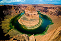 |
|
|
|
05/27/2010 09:54:04 AM · #11 |
Originally posted by alanfreed:
While you're in Page, don't miss Horseshoe Bend! It's easy to whiz right past it at 75 mph... but it's tremendously worth a stop. It's just south of Page:
|
where...as I did miss it last year... |
|
|
|
05/27/2010 10:24:15 AM · #12 |
Originally posted by Ja-9:
where...as I did miss it last year... |
It's along Route 89 just south of Page. There is an easy-to-miss sign along the road that says "Horseshoe Bend," with a little parking lot on the western side of the road. You can't see the river from the road... there's a little hike involved. You can park in the little dirt lot and hike up some switchbacks, and then down the other side to the overlook. It's not a terribly strenuous hike... maybe 10 minutes at the most.
I included the GPS coordinates for it in my notes on that shot.
EDIT: These are the coordinates for the parking area: N36 52.596 W111 30.170
Message edited by author 2010-05-27 10:46:47. |
|
|
|
05/27/2010 12:32:22 PM · #13 |
Originally posted by alanfreed:
Originally posted by Ja-9:
where...as I did miss it last year... |
It's along Route 89 just south of Page. There is an easy-to-miss sign along the road that says "Horseshoe Bend," with a little parking lot on the western side of the road. You can't see the river from the road... there's a little hike involved. You can park in the little dirt lot and hike up some switchbacks, and then down the other side to the overlook. It's not a terribly strenuous hike... maybe 10 minutes at the most.
I included the GPS coordinates for it in my notes on that shot.
EDIT: These are the coordinates for the parking area: N36 52.596 W111 30.170 |
got it Alan, we do have a GPS, just wish I had a fisheye that I could take...that's a perfect place to use that isn't it......I also looked at the satellite view on Google...I think I see where it is...it just right out of Page isn't it |
|
|
|
05/27/2010 03:18:23 PM · #14 |
Yep... just a couple miles south of Page. You can actually put those coordinates into Google Earth's search field and it will zoom right to it. And yes, a wide-angle lens of some sort is definitely a huge help there. I used my 10-20 to get shots of it, and I was very thankful to have that width!
Originally posted by Ja-9:
Originally posted by alanfreed:
Originally posted by Ja-9:
where...as I did miss it last year... |
It's along Route 89 just south of Page. There is an easy-to-miss sign along the road that says "Horseshoe Bend," with a little parking lot on the western side of the road. You can't see the river from the road... there's a little hike involved. You can park in the little dirt lot and hike up some switchbacks, and then down the other side to the overlook. It's not a terribly strenuous hike... maybe 10 minutes at the most.
I included the GPS coordinates for it in my notes on that shot.
EDIT: These are the coordinates for the parking area: N36 52.596 W111 30.170 |
got it Alan, we do have a GPS, just wish I had a fisheye that I could take...that's a perfect place to use that isn't it......I also looked at the satellite view on Google...I think I see where it is...it just right out of Page isn't it |
|
|
|
|
05/27/2010 03:22:16 PM · #15 |
Originally posted by alanfreed:
Yep... just a couple miles south of Page. You can actually put those coordinates into Google Earth's search field and it will zoom right to it. And yes, a wide-angle lens of some sort is definitely a huge help there. I used my 10-20 to get shots of it, and I was very thankful to have that width!
Originally posted by Ja-9:
Originally posted by alanfreed:
Originally posted by Ja-9:
where...as I did miss it last year... |
It's along Route 89 just south of Page. There is an easy-to-miss sign along the road that says "Horseshoe Bend," with a little parking lot on the western side of the road. You can't see the river from the road... there's a little hike involved. You can park in the little dirt lot and hike up some switchbacks, and then down the other side to the overlook. It's not a terribly strenuous hike... maybe 10 minutes at the most.
I included the GPS coordinates for it in my notes on that shot.
EDIT: These are the coordinates for the parking area: N36 52.596 W111 30.170 |
got it Alan, we do have a GPS, just wish I had a fisheye that I could take...that's a perfect place to use that isn't it......I also looked at the satellite view on Google...I think I see where it is...it just right out of Page isn't it |
|
ya, well all I have is a 18-135mm and I'm thinking that's NOT what I need...oh well..it's what I have... |
|
|
|
05/27/2010 03:23:26 PM · #16 |
Originally posted by Ja-9:
ya, well all I have is a 18-135mm and I'm thinking that's NOT what I need...oh well..it's what I have... |
Well, that's why God created the idea of stitching shots into a panorama ;) |
|
|
|
05/27/2010 03:54:24 PM · #17 |
You don't describe what type of vehicle you will be drive because some of the places I mention might require a 4W drive SUV.
New Mexico on way to Monument Valley:
1-Bisti and De-Na-Zin Wilderness - this is one of the best and least visited world class photo sites in New Mexico... different from all other places you'll visit
Bisti Badlands
2-Chaco Canyon Anasazi Ruins - 20 miles or so south of Bisti and the site of the famous Anasazi solar/lunar calendar petroglyph on Fajada Butte.
Monument Valley:
You could easily spend several days here. I recommend a minimum of one sunrise and one sunset... drive the self-guided loop drive at the Navajo Tribal Park and don't miss John Ford Point just off the loop... the famous Forrest Gump movie site photo op is outside the Tribal Park and about 10-15 miles north on Hwy 163 toward Mexican Hat near the top of a long sloping hill.
Page, AZ area:
1-Antelope Canyon (Lower Antelope will have fewer people to get in the way)... be sure to pay extra for the photographer tour that is longer)
2-Horseshoe Bend (5 miles south of Page... has a big sign and paved parking lot now... about a .7 mile hike over a sloping hill to the edge and back... don't fall off)
3-Toadstool Hoodoos (about 20 miles or so west of Page,AZ just off hwy 89... some the world's most photographed hoodoos)
4-Wahweap Hoodoos (also called the White Hoodoos or the "Towers of Silence"... 5 miles east of Page to Big Water and a 4+ mile hike north)
5-The Tropic Shale (follow Smokey Mountain Rd out of Big Water several miles... spectacular panoramic vistas of a moonscape framed by a looming, majestic plateau of white cliffs called the Kaiparowits)
6-Other secret and spectacular hoodoo sites and many other photo ops in the area. ;)
I can supply more information if interested
PS to  Ristyz... Ristyz...
I know a very special SUPER secret photo op near you. When I'm down that way again and if you are interested I will show it to you. I call it the place of the Suevi Warriors though it has a different real name. ;)
Message edited by author 2010-05-27 16:14:49.
|
|
|
|
05/27/2010 03:55:03 PM · #18 |
Even with my 10-22mm it barely covered horseshoe bend, stitching together a pano would work just as good I think with a solid tripod.
ETA: DONT be walking and looking through the viewfinder ;) theres no railings and the first 700' step is a nasty one.
Message edited by author 2010-05-27 15:56:02.
|
|
|
|
05/27/2010 04:03:00 PM · #19 |
Originally posted by PhotoDave:
Even with my 10-22mm it barely covered horseshoe bend, stitching together a pano would work just as good I think with a solid tripod.
ETA: DONT be walking and looking through the viewfinder ;) theres no railings and the first 700' step is a nasty one. |
Actually, that first step will take you all the way to the river... 1,360 feet STRAIT down according to my GPS topo map. I've been there and leaned over that cliff. Its scary!
Message edited by author 2010-05-27 16:04:33.
|
|
|
|
05/27/2010 04:14:03 PM · #20 |
Originally posted by Artifacts:
PS to Ristyz...
I know a very special SUPER secret photo op near you. When I'm down that way again and if you are interested I will show it to you. I call it the place of the Suevi Warriors though it has a different real name. ;) |
Cristy!...be sure to bring your own GPS with you...Steve cannot be trusted with directions...and we don't want to lose you! ;-P |
|
|
|
05/27/2010 04:21:28 PM · #21 |
Originally posted by hihosilver:
Originally posted by Artifacts:
PS to Ristyz...
I know a very special SUPER secret photo op near you. When I'm down that way again and if you are interested I will show it to you. I call it the place of the Suevi Warriors though it has a different real name. ;) |
Cristy!...be sure to bring your own GPS with you...Steve cannot be trusted with directions...and we don't want to lose you! ;-P |
She's safe... I take a GPS fully loaded with topo maps for all the western states everywhere I go now. It comes in handy walking the slick rock of the Grand Staircase where there are few real trails or trail markings and everything looks the same.
And I always set a waypoint for my starting point. :)
|
|
|
|
05/27/2010 04:23:28 PM · #22 |
oh, wow...these are some great places!! Just what I was looking for...
we are driving in a Suburban (or similar) but it's rental so therefore...nothing crazy (will have to stay clear of my Brother and Brother-in-Law as they have a tendency to "go JUST a little more"...)
we arrive in Albuquerque, NM then drive to Santa Fe for a night...Durango area for a wk (we're all over the blip map here), then Monument Valley, Page, (I'd like to slip in Horseshoe Canyon/River) Grand Canyon (Eastern side of the South Rim) and back to Santa Fe for 4 days...this should be quite the trip....
I've marked this thread so I can reference it while on the trip and when we get time we will go a wander'n :)
Thanks again...and if anyone has any place else to add...sure would love it...to me this is probably one of the best things about this site...sharing |
|
|
|
05/28/2010 01:07:28 AM · #23 |
A PS to Monument Valley. You absolutely HAVE to get ther before 5pm or you can't get in the park area for a sunset shot. I tried it last spring just after the time changed.
Steve, I would welcome you anytime. (If I'm not "stuck" at a horse show already that is!)
Originally posted by Artifacts:
Monument Valley:
You could easily spend several days here. I recommend a minimum of one sunrise and one sunset... drive the self-guided loop drive at the Navajo Tribal Park and don't miss John Ford Point just off the loop... the famous Forrest Gump movie site photo op is outside the Tribal Park and about 10-15 miles north on Hwy 163 toward Mexican Hat near the top of a long sloping hill.
PS to Ristyz...
I know a very special SUPER secret photo op near you. When I'm down that way again and if you are interested I will show it to you. I call it the place of the Suevi Warriors though it has a different real name. ;) |
|
|
|
|
05/28/2010 01:08:29 AM · #24 |
Janine... lens rental is not very expensive, even for a couple of weeks.
Originally posted by Ja-9:
Originally posted by alanfreed:
While you're in Page, don't miss Horseshoe Bend! It's easy to whiz right past it at 75 mph... but it's tremendously worth a stop. It's just south of Page:
|
where...as I did miss it last year... |
|
|
|
|
05/28/2010 01:16:30 AM · #25 |
"Drive it like a rental car!!!" (with insurance)
SUV's are the new Rez Rockets... once upon a time it was only pick-ups or Cameros.
Sounds to me like you are gonna fill that 2 weeks easily. Now around Santa Fe definitely hit Bandolier. And go north to spend a little time in Taos and the Rio Grand Canyon. Listen for the Taos Hum. If you really like Trains there is another on out of Chama, NM which is in between Durango and Taos of you go via Pagosa Springs or Ignacio. Santa Fe is the 3rd largest art district in the US after NY and LA last I head so lots of galleries to look through there. Rodeo Drive and old downtown are the two hot spots.
Originally posted by Ja-9:
oh, wow...these are some great places!! Just what I was looking for...
we are driving in a Suburban (or similar) but it's rental so therefore...nothing crazy (will have to stay clear of my Brother and Brother-in-Law as they have a tendency to "go JUST a little more"...)
we arrive in Albuquerque, NM then drive to Santa Fe for a night...Durango area for a wk (we're all over the blip map here), then Monument Valley, Page, (I'd like to slip in Horseshoe Canyon/River) Grand Canyon (Eastern side of the South Rim) and back to Santa Fe for 4 days...this should be quite the trip....
I've marked this thread so I can reference it while on the trip and when we get time we will go a wander'n :)
Thanks again...and if anyone has any place else to add...sure would love it...to me this is probably one of the best things about this site...sharing |
|
|


