| Author | Thread |
|
|
12/06/2007 10:33:28 AM · #26 |
| Thanks to all of you who helped me figure out that posting thumbs was actually very easy...Thanks also to that special person in OHIO for your help. |
|
|
|
12/09/2007 09:53:25 AM · #27 |
Stillwater Covered Bridge - Stillwater, PA
The Stillwater Covered Bridge crosses over Big Fishing Creek in the Borough of Stillwater. This covered bridge has a length of 168 feet and was built by James McHenry in 1849 for a cost of only $1,124. It is a Burr Arch truss with a herringbone wood deck & is supported by The Theodore Burr Covered Bridge Society of Pennsylvania, Inc. The Theodore Burr Covered Bridge Society was named in honor of the famous Theodore Burr, who was known for the Burr Arch construction of covered bridges. This link has a drawing to show the details of the Burr Arch construction: //www.in.gov/dnr/historic/bridgeburrarch.html

Josiah Hess Covered Bridge - Village of Forks, PA
The Josiah Hess covered bridge is located between the Village of Forks and Jonestown. It was constructed by Joseph Redline in 1875 at a cost of $1,349.50 and was named for the Hess family who owned a sawmill and nearby farm. It is a Burr Arch Truss with a total length of 110 feet.
The Twin Bridges (East & West Paden) - Village of Forks, PA
W.C. Pennington built the Twin Bridges in 1884 at a cost of $720, the bridge was named after John Paden, who operated a nearby sawmill. The East Paden was damaged by an arsonist in 2004, after $316,000 in repairs it was reopened & dedicated in May 2006. Exactly one month after the dedication the West Paden collapsed when the Huntington Creek flooded. The East & West Paden had been the only twin covered bridges in the country, the West Paden bridge has not yet been repaired.
|
|
|
|
12/09/2007 03:55:35 PM · #28 |
the Zaan
It's not easy to tell the story of an old water with 3 photos and just 100 words, but here's an attempt (and I had a very nice walk on on a sunny sunday morning)
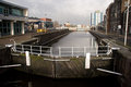
Entrace to the Zaan
This lock (Wilhelminasluis) in the centre of Zaandam, is the south entrance to the Zaan. It's from 1903 and it can be very busy here, but not on this cold sundaymorning in December.
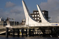
Prins Bernhardbrug
There are a lot of bridges here. This is the newest one (official opened on Dec 15, 2006). In januari they are going to replace another one (takes about 1 1/2 year).
Industry
There has always been a lot of industry near the Zaan since Amsterdam forbid the use of woodmills at the end of the 16th century. And of course you have fisherman.
|
|
|
|
12/12/2007 02:10:28 AM · #29 |
Neon Blade Signs of Durham, North Carolina
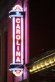
One of the oldest and most treasured neon signs of Durham is the Carolina Theater sign. Lighting up downtown and inviting patrons inside over 80 years after the theater saw its first guests.

The neon sign lighting the way to the Symposium Cafe is quite a bit newer than the old standby at the Carolina Theater, but adds to the rich tradition of gorgeous neon signs lighting up the Durham night sky.
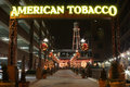
Finally, this sign is the welcoming committee to the American Tobacco Campus. Nestled in downtown Durham this downtown rejuvenation is located across from the Durham Bulls athletic park and is home to gorgeous water features, cafes, restaurants, North Carolina Public Radio, and office spaces. Whether they be older or newer the neon blade signs of Durham invite a closer look! |
|
|
|
12/13/2007 02:19:37 PM · #30 |
Thanks to  JerseyGenie for allocating me the assignment on Watling Street JerseyGenie for allocating me the assignment on Watling Street
Watling Street
Watling Street is an ancient celtic trackway and Roman Road that runs for several hundred miles in the UK. Steeped in history this is the story of just 75 metres of its length
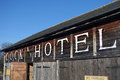
The Cock Hotel Stables
Watling Street used to be the main route for journeys from Dover and London to the Midlands and North. Built in 1470 The Cock Hotel was often a stopping of place for horse drawn coaches. This is the stables at the rear of the hotel. Frequently travellers would rest at the Cock Hotel and change their horses here. In the nursery rhyme 'Ride A Cockhorse To Banbury Cross', a 'cockhorse' refers to a horse that was hired from the Cock Hotel
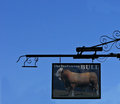
The Bull Inn
Just fifty metres up from the Cock Hotel is another famous historic coaching inn, The Bull. Legend has it that travellers staying at either of the inns would tell stories of there journeys, which would then be retold at the other inn. However in the time they took to pass from one place to the other they were often mightily exagerated which gave rise to the expression 'A Cock and Bull Story'. It was also at the Bull that the 'Great Fire of Stony Stratford' started in 1742 when a chambermaid, afraid of being reprimanded for burning a sheet whilst ironing it, stuffed the sheet up a chimney. The fire reached the thatch and spread along the buildings destroying virtually all the southern end of the town

The Old Rose and Crown
Another 25 metres down the road is a third coaching inn, however this one is now residential units. The small plaque on the wall denotes a black page of English History as it is here in 1483 where the uncrowned boy King, Edward V, was captured by his uncle Richard Duke of Gloucester, who later became King Richard III. From this spot he was taken to the Tower of London and he and his brother (the Princes in the Tower) were later executed
Message edited by author 2007-12-13 14:19:57. |
|
|
|
12/14/2007 12:56:59 PM · #31 |
| Rex...I appologize for screwing up my posts, but I figured it out - now wondering about my scores on the Marietta Square???? |
|
|
|
01/02/2008 01:23:39 PM · #32 |
Just thought I'd give this a bump after the holidays.... still patiently awaiting my score :)
|
|
|
|
01/02/2008 01:52:01 PM · #33 |
Originally posted by Caroline69:
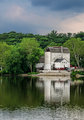
St.Esprit, Quebec Canada
Founded in 1808, the village of St.Esprit was colonized mostly by deported Acadians, who sprawled across the region and created lots of tiny villages that still surround St.Esprit: St.Jacques (where I live), St.Alexis, and such.
The village gets its name from the river that runs through it. Acadians being very religious, the church was given a prominent place within the village, at the center of the main place.

Many of the houses on the main street date back to these earlier days, when Acadians settled in this region they called New Acadia. Some of them have been restored to a new beauty, full of color.

The village revolves mostly around agriculture and there is no real attraction there. Many of the farmers own maple groves, passed through families for decades.

Each year, at spring, for a short time, it's sugar shack season. Tourists come from around the province to get a taste of what some call the best maple syrup in Quebec. Made by boiling the maple sap into a sugary syrup, it accompanies other traditional meals like baked beans and fried pork rinds. |
This is the Critique and Rules I will follow when Commenting on your finished work..
#1.....DO photos Match Assignment ( 3 Photos Max )................ Yes, they do. 10 points
#2.....Do photos selected Interest the Viewer............................. 1 to 10 Points yes. 10 points
#3.....Do photos MATCH the Manuscript Paragraphs ( 100 Word Max. and can be
Shorter than this ) Each Photo (3) requires a Paragraph.......... 1 to 10 Points yes. 10 points
#4.....Composition on each Separate Photo'
Photo 1................................................. .................. 1 to 10 Points
This is simply beautiful. You have used the road as leading lines to lead directly to the church. 10 points
Photo 2 .................................................. ................ 1 to 10 Points
I love the colors in this. Also, the focus is right on -- the house on the right is so crisp and clear. Oddly enough, contradicting Rex, it feels as if the shot is tilted to the right to me. When you look at the house on the right, it is not, but I think because of the partial building on the left looking tilted, and because the eye naturally follows the road to the horizon, which seems tilted, it has that effect. Still a nicely done shot. 9 points
Photo 3 .................................................. ................ 1 to 10 Points
I really like the balance this shot has. The sky, though large, does not overwhelm the snow, and the tree line adds interest to the horizon. 10 points
#5.... Technicals... DOF Choice/ Focus/ etc..
Photo 1................................................. .................. 1 to 10 Points
Also, the colors of the sky contrast very nicely with the yellowish cast of the lights. VERY well done. 10
Photo 2................................................. .................. 1 to 10 Points
I love the colors in this. Also, the focus is right on -- the house on the right is so crisp and clear. 10 points
Photo 3 .................................................. ................ 1 to 10 Points
The snow looks blue, which is common, and could be reflecting the sky. However, it does make it seem to have a bluish cast to it. 8 opints
#6 Overall Presentation .................................................. ..... 1 to 10 Points
A wonderful set of shots. I enjoyed looking at them and reading about them. Thanks for sharing! 10 points
______________
Score ---------> 97
Message edited by author 2008-01-02 14:08:03. |
|
|
|
01/02/2008 02:35:43 PM · #34 |
Originally posted by bs-photos:
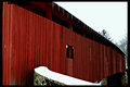
Stillwater Covered Bridge - Stillwater, PA
The Stillwater Covered Bridge crosses over Big Fishing Creek in the Borough of Stillwater. This covered bridge has a length of 168 feet and was built by James McHenry in 1849 for a cost of only $1,124. It is a Burr Arch truss with a herringbone wood deck & is supported by The Theodore Burr Covered Bridge Society of Pennsylvania, Inc. The Theodore Burr Covered Bridge Society was named in honor of the famous Theodore Burr, who was known for the Burr Arch construction of covered bridges. This link has a drawing to show the details of the Burr Arch construction: //www.in.gov/dnr/historic/bridgeburrarch.html
Josiah Hess Covered Bridge - Village of Forks, PA
The Josiah Hess covered bridge is located between the Village of Forks and Jonestown. It was constructed by Joseph Redline in 1875 at a cost of $1,349.50 and was named for the Hess family who owned a sawmill and nearby farm. It is a Burr Arch Truss with a total length of 110 feet.
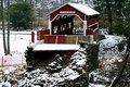
The Twin Bridges (East & West Paden) - Village of Forks, PA
W.C. Pennington built the Twin Bridges in 1884 at a cost of $720, the bridge was named after John Paden, who operated a nearby sawmill. The East Paden was damaged by an arsonist in 2004, after $316,000 in repairs it was reopened & dedicated in May 2006. Exactly one month after the dedication the West Paden collapsed when the Huntington Creek flooded. The East & West Paden had been the only twin covered bridges in the country, the West Paden bridge has not yet been repaired. |
This is the Thread, to post your Finished Assignments... If you are Interested in an assignment, PLEASE SEE ----> "Local Assignment Thread" and I will give you an Assignment..
This is the Critique and Rules I will follow when Commenting on your finished work..
#1.....DO photos Match Assignment ( 3 Photos Max )................ 1 to 10 Points yes. 10 points
#2.....Do photos selected Interest the Viewer............................. 1 to 10 Points yes. 10 points
#3.....Do photos MATCH the Manuscript Paragraphs ( 100 Word Max. and can be
Shorter than this ) Each Photo (3) requires a Paragraph.......... 1 to 10 Points yes. 10 points
#4.....Composition on each Separate Photo'
Photo 1................................................. .................. 1 to 10 Points
I really like how the bridge pulls the viewer's eyes through the frame. That is very effective, I think. 10
Photo 2 .................................................. ................ 1 to 10 Points
Strangely enough, even though the bridge is in the middle, the composition still feels balanced. I like how the river leads up and through the frame. 10 points
Photo 3 .................................................. ................ 1 to 10 Points
I like the perspective you have chosen for this. It gives a good overview of the area, but still maintains the beauty of the covered bridge. It may be a bit too centered - it feels as if it should be just a hair further to the right in the frame, but the hint of the orange construction fence leads me to think there may have been a reason to crop it. 9 points
#5.... Technicals... DOF Choice/ Focus/ etc..
Photo 1................................................. .................. 1 to 10 Points
The whites looks a touch on the bright side, but the red is a nice color and the icicles add a lot to the shot. 9 points
Photo 2................................................. .................. 1 to 10 Points
It seems a touch dark on my monitor, but any brighter, and the white in the snow may blow out. If not for the nice red of the bridge, I would recommend a high contrast bw for this. 9 points
Photo 3 .................................................. ................ 1 to 10 Points
The focus is okay, though it does seem to be just a bit off -- as evidenced by the words over the bridge opening. I'm wondering if this is an effect from resizing. Nicely shot, and I like the level of contrast in this one. 9 points
#6 Overall Presentation .................................................. ..... 1 to 10 Points
Great series of shots. I like the history you have provided and how they all tie together. I'm thinking they would make a nice triptych as well. 10 points
______________
Score ---------> 96 |
|
|
|
01/04/2008 10:04:37 AM · #35 |
Thanks  karmat! This has been super fun to do and the shot of the church is now a favorite of mine! karmat! This has been super fun to do and the shot of the church is now a favorite of mine! |
|
|
|
01/06/2008 01:14:29 PM · #36 |
I live outside of Harrisburg, Pennsylvania, the capital city of the state, which is built on the banks of the Susquehanna river. The city is centrally located in the Keystone State, so named because of its importance to commerce and transportation between points north and the transit from the south and west. There are a total of nine bridges across the Susquehanna, and they are most important to this transportation system. This is one of the railroad bridges that is over 100 years old with its predecessor to the left.
[thumb]625405[/thumb]
The Harrisburg area is also where the Enola Yard and the Rutherford Intermodal Yard service train traffic on both the East and West shores of the Susquehanna. This is a pretty typical sight on any given day.
[thumb]624845[/thumb]
If you're a fan of rivers, trains, and beautiful old bridges, this area has a lot to offer, this last image being pretty much the culmination of the rail scene. This is the Rockville Bridge, the longest stone arch railroad bridge in the entire world at 3823 feet and 48 arches!
[thumb]492042[/thumb]
It has been able to withstand major floods, economic distresses, over 100 years of service, and is still going strong.
|
|
|
|
01/06/2008 04:43:19 PM · #37 |
Sorry I kinda dropped off on this. Just been kinda busy with the holidays and my website. I will hopefully get these caught up in the next week or so. If anyone else wants to come in and grade then by all means help.
|
|
|
|
01/06/2008 05:32:15 PM · #38 |
I was trying to wait for pretty snow to set up some of these shots. I gave up waiting and used some of my existing shots. Now that I've given up, it'll probably snow tomorrow! Edit to say now 1/30 and still no snow, to speak of!! Boo Hiss.
The Historic Delaware River
The Delaware River plays several important roles in American history.
State by State
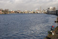
The Delaware River forms the entire border between New Jersey and Pennsylvania. The river also forms part of the border between New Jersey and New York and creates most of the border between New Jersey and Delaware. I'm standing in NJ and shooting across the river at PA.
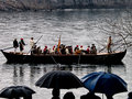
Starred a Pivotal Role in American History
On Christmas Day in 1776, General George Washington led his revolutionary troops across the river. The next morning they attacked the Hessian troops in the historic Battle of Trenton. Artist, Emanuel Leutze, portrayed that crossing in his famous painting. Each year, weather permitting, the crossing is recreated. (While this is not a stellar photo, it reminded me of Renoir�s �The Umbrellas� piece.)
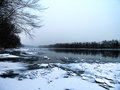
Weather and the River
The river�s location near the United States� Atlantic coast lends itself to weather related events. Winter and heavy snow has led to historic flooding. And yet the rains most often associated with summer and the hurricane season also wreak havoc.
Message edited by author 2008-01-30 21:11:17. |
|
|
|
01/26/2008 11:05:12 PM · #39 |
Pokagon Toboggans
My assignment (back on Dec 3) was: �Pokagon State Park ... one we would want one of the photos to be the toboggans.� Now, Pokagon is about an hour\'s drive from my house, and what with only being able to shoot on the weekends and with Christmas & New Years, etc. this was my first opportunity.
(Note to ed. - the intro paragraph and paragraph under 1st picture combined are less than 100 words total. Do you really expect me to do this with just three pictures?!)
---
Pokagon State Park is near the NE corner of Indiana, in an area with lots of lakes and natural beauty. It offers a full-service inn, horseback riding, camping, swimming, cross-country skiing, and, of course, The Toboggan Run!

The toboggan run started in 1935, and currently boasts side-by-side refrigerated tracks that drop from a 30 foot tall tower to start their quarter-mile run. On a chilly Saturday in January, people are lined up waiting their turn as a sled comes out of the tower and rockets down the hill.

With a total drop of 90 feet in elevation, sitting on an open sled inches from the ice whizzing by at speeds of up to 42 miles per hour, to say the run is a rush is a huge understatement. The smiles (and screams) of the young and old alike say it all.

From the bridge over the parallel tracks about three quarters through the run, spectators can watch the sleds ease out of the tower and rush down the track, flying underneath their vantage point, past the end of the tracks, and out onto the lawn of the Potawanomi Inn. For more information - plus a video of a toboggan run, visit tobogganrun.com. Now, if you�ll excuse me, I�ve got to get my sled back up the hill.
|
|
|
|
01/29/2008 07:11:00 PM · #40 |
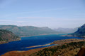
The Vista House, Oregon.
The Vista House sits on top of Crown Point along the Columbia River. Construction started in 1918, shortly after the opening and dedication of the Columbia River Highway from Portland to Hood River and cost about $100,000 to build.
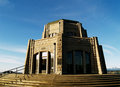
The interior of the Vista House ranges from marble floors and brass fixtures to the beautiful stained glass in the windows. It is both a memorial to "the trials and hardships of those who had come into the Oregon country" and a comfort station to those travelling along the Highway.
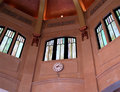
The view from the Vista House is quite astonishing. You can see the Columbia river for miles, in both directions.
 |
|
|
|
01/29/2008 08:21:24 PM · #41 |
I am going to NC tomorrow for work and when I come back Friday morning I will try and catch these up.
Also if anyone wants to help then by all means help!
|
|
|
|
02/02/2008 08:02:52 PM · #42 |
secretagent65 - Thanks for doing The Vista House. The road goes almost all the way around the building in a very sharp curve, and I remember my older brother driving our family car around the corner fast enough to make the tires squeal all the way. Of course, dad wasn't in the car... I also drove that road as part of my driver's ed class at David Douglas High School in Portland. The Columbia River Gorge is beautiful, and Multnomah Falls is just up the road a piece. Your article makes me want to go back.
Message edited by author 2008-02-02 20:03:40. |
|
|
|
02/05/2008 10:27:57 PM · #43 |
Originally posted by dtremain:
secretagent65 - Thanks for doing The Vista House. The road goes almost all the way around the building in a very sharp curve, and I remember my older brother driving our family car around the corner fast enough to make the tires squeal all the way. Of course, dad wasn't in the car... I also drove that road as part of my driver's ed class at David Douglas High School in Portland. The Columbia River Gorge is beautiful, and Multnomah Falls is just up the road a piece. Your article makes me want to go back. |
I love Oregon... are you far away from here now? |
|
|
|
02/06/2008 09:05:54 PM · #44 |
Originally posted by secretagent65:
I love Oregon... are you far away from here now? |
Sadly, yes. NE Indiana. I miss the hills and mountains the most. Indiana has its own beauty, but it is more subtle. |
|
|
|
02/22/2008 08:32:15 PM · #45 |
|
|
|
02/22/2008 10:56:18 PM · #46 |
Originally posted by JerseyGenie:
BUMP |
Yep, I took my photos back in January - just haven't had time to do them justice yet. However, I think I'll have plenty of time after 10th March to do them. ;-Þ |
|
|
|
03/03/2008 12:34:14 PM · #47 |
|


